&w=3840&q=75)
&w=3840&q=75)
&w=3840&q=75)
&w=3840&q=75)
&w=3840&q=75)
&w=3840&q=75)
&w=3840&q=75)
&w=3840&q=75)


322
[ATLAS]. ROBERT DE VAUGONDY (Gilles et Didier) Atlas Universel par M. Robe
The item was sold for 4 549 €
Fees include commission and taxes.
[ATLAS]. ROBERT DE VAUGONDY (Gilles et Didier) Atlas Universel par M. Robert, géographe ordinaire du Roy, et par M. Robert de Vaugondy, son fils, géographe ordinaire du Roy.
Paris, chez les auteurs et Boudet, 1757. In-folio, old-fashioned demibasane, 6-ribbed spine, garnet-red morocco title-piece, red edges (flaws including badly worn corners, torn off headpieces| some soiling and stains in the margins of the maps, tear.
one map repaired in margin| without list of subscribers p.35-40).
One of the most accurate and elegant French atlases of the 18th century, with 1118 copies sold by subscription.
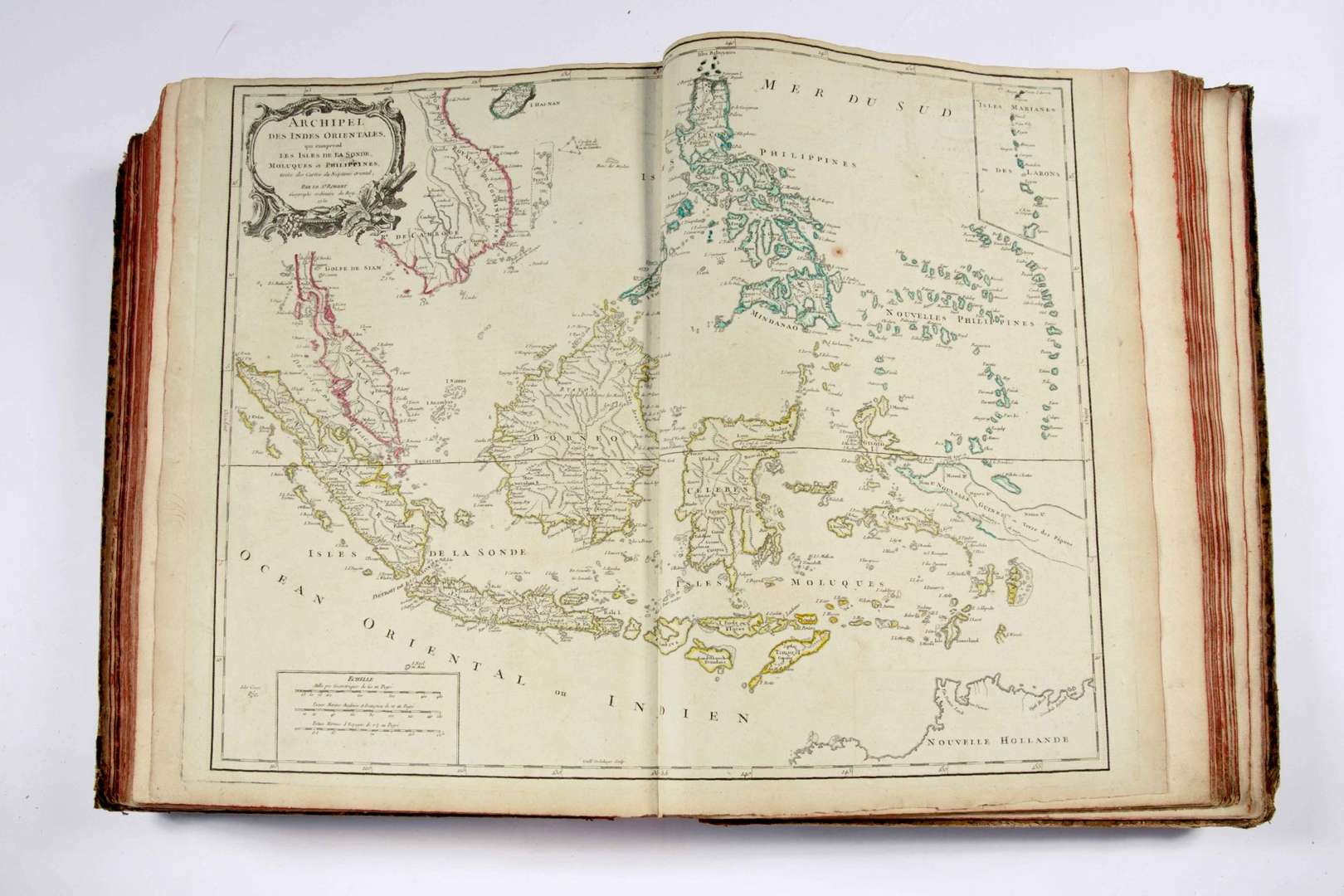
It features a frontispiece title engraved by Ch. Bacquoy, 34 pages of explanatory text in two columns, and 108 mitered maps, most of them double-page, plus 8 additional maps, for a total of 116 maps. Each map is adorned with a decorative cartouche, drawn by Pierre-Philippe Choffard and engraved by Elisabeth Haussard (Cohen, 589), and the boundaries are colored.
The King's geographer Gilles Robert (1688-1766) designed this atlas, drawing on material acquired through the purchase of Nicolas Sanson's collection, and carrying out new research with the collaboration of his son Didier Robert de Vaugondy (1723-1786).
The maps were engraved according to the most recent knowledge of the time, and served as a reference throughout the second half of the 18th century. In particular, the atlas contains several important maps of America (North America|
Canada| English Colonies| Virginia, Maryland, Pennsylvania|
South America| Greater and Lesser Antilles| Saint-Domingue and La Martinique| and on the Middle and Far East (European Turkey| Asian Western Russia| Asian Eastern Russia| East India Archipelago| China| Japan, etc.).
Enclosed are two handwritten maps on Holland laid paper, one of the islands of Tenerife and Madeira, the other of the Cape Verde islands.
Paris, chez les auteurs et Boudet, 1757. In-folio, old-fashioned demibasane, 6-ribbed spine, garnet-red morocco title-piece, red edges (flaws including badly worn corners, torn off headpieces| some soiling and stains in the margins of the maps, tear.
one map repaired in margin| without list of subscribers p.35-40).
One of the most accurate and elegant French atlases of the 18th century, with 1118 copies sold by subscription.
It features a frontispiece title engraved by Ch. Bacquoy, 34 pages of explanatory text in two columns, and 108 mitered maps, most of them double-page, plus 8 additional maps, for a total of 116 maps. Each map is adorned with a decorative cartouche, drawn by Pierre-Philippe Choffard and engraved by Elisabeth Haussard (Cohen, 589), and the boundaries are colored.
The King's geographer Gilles Robert (1688-1766) designed this atlas, drawing on material acquired through the purchase of Nicolas Sanson's collection, and carrying out new research with the collaboration of his son Didier Robert de Vaugondy (1723-1786).
The maps were engraved according to the most recent knowledge of the time, and served as a reference throughout the second half of the 18th century. In particular, the atlas contains several important maps of America (North America|
Canada| English Colonies| Virginia, Maryland, Pennsylvania|
South America| Greater and Lesser Antilles| Saint-Domingue and La Martinique| and on the Middle and Far East (European Turkey| Asian Western Russia| Asian Eastern Russia| East India Archipelago| China| Japan, etc.).
Enclosed are two handwritten maps on Holland laid paper, one of the islands of Tenerife and Madeira, the other of the Cape Verde islands.